A new model of forest ownership for the West

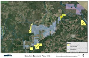
In 2011, the Mt. Adams Community Forest was established as Washington’s first non-profit owned, working community forest
Community members and friends of Mt. Adams Resource Stewards rallied behind an opportunity to bring home ownership of the Glenwood Valley’s Mill Pond, raising funds that provided for the outright purchase of the 100 acre property. The 2011 achievement was significant in a number of ways and MARS’ management of the Mill Pond’s productive forests, restoration opportunities, water and recreation resources is a work in progress (see below). In July of 2014, the forest expanded with the completion of a second acquisition: the 300 acre Pine Flats Forest located along a county highway between Trout Lake and Glenwood. Since then, MARS has completed four additional land purchases (as of September 2023), expanding the community forest ownership to over 1,800 acres. MARS continues to work with partners on efforts to expand the Mt. Adams Community Forest through additional purchases, while growing a locally meaningful model of conservation and stewardship for the Mt. Adams region. The Mt. Adams Community Forest strives to permanently protect high community and conservation value forests critical to the quality of life of our region. Management goals for community forest properties are centered around principles of land stewardship, community benefit, and healthy, functioning ecosystems. Such goals recognize the value of sustainably managed forest resources as a renewable source of wood products and jobs, balanced with the provision of habitat for flora and fauna, and public access for recreation. Tradition is an important element of the Mt. Adams Community Forest vision, and activities such as fishing, hunting, and firewood gathering are provided for when possible. Management of the forest is the responsibility of MARS staff under the direction of its Board of Directors. Community input is particularly important to the Board, and each year community members provide guidance on management priorities through public listening sessions and direct recommendations from our community advisory committee.
Mt. Adams Community Forest Properties
Learn more about specific community forest properties, including history, ecology, and access information below. Mill Pond Tract
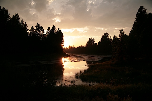
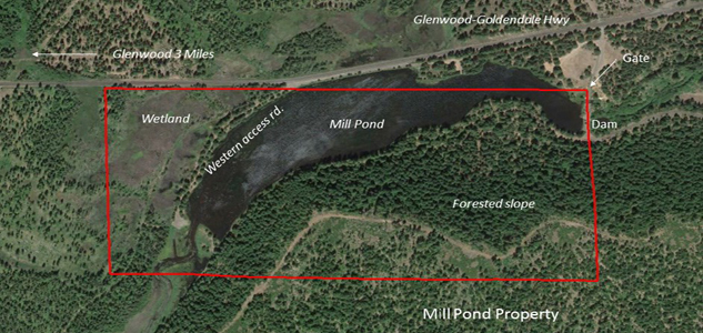 The 288-acre Mill Pond-Outlet Creek tract lies approximately 3 miles east of Glenwood, on the south side of the Goldendale-Glenwood Highway. The pond itself is adjacent to the road, making it hard to miss. The property includes the pond – about 22 acres in size, some wetland areas west and north of the pond, and upland forests to the south. As the name suggests, the property was once the site of a bustling sawmill operation. In the 1920’s, the sawmill was owned by Portland’s Collins Family and known as the Mt. Adams Lumber Company. The J. Neils Lumber Company purchased Collins’ Glenwood holdings in the 1930’s and subsequently closed the mill, consolidating operations around a lumber plant in the town of Klickitat. The pond has never been a natural feature; a small dam holds back Outlet Creek, creating the pond and surrounding wetlands. Old railroad grades that were once used to transport logs for “dumping” in the Mill Pond can be found on the north side, and an old flume once transported timber from surrounding hills down the slope to the south of the water feature. Most of the Mill Pond tract consists of second growth, conifer forest. Pictures of the hillside from the 1920’s show a mostly barren landscape that had been recently logged and burned. A bench at the southern edge of the property was harvested by a previous landowner and contains scattered remnant Oregon white oak and pockets of ponderosa and Douglas-fir. The area has been the subject of restoration efforts and volunteers helped to replant portions of this area with seedlings donated by Hancock Forest Management in 2012. Denser stands closer to the Mill Pond have been the focus of recent commercial thinning efforts by MARS. These thinnings are designed to release the larger pine and Douglas-fir and generate income for community forest management needs. A recent harvest unit north of Outlet Creek and west of the Mill Pond occurred before MARS purchased this addition to the property in 2019. The previous landowner’s expertise in reforestation leaves MARS with a future forest, in addition to expanded community access/public recreation opportunities, across this portion of the property. MARS is in the process of developing a trail along the south side of Outlet Creek following the 2019 purchase. Community volunteers and MARS stewardship crew staff have had a hand in converting an old “cow trail” into a footpath that can better serve regular traffic. The property is open to hiking and hunting. In the spring it is host to migrating waterfowl, and volunteers have located wood duck nesting boxes strategically around the shore. Swimming in the pond is not recommended due to past reports of “swimmers itch,” but it does provide for casual canoeing and kayaking opportunities as well as ice-skating in the winter when the weather cooperates. Motorized craft are not permitted on the Mill Pond. The Mill Pond tract can be accessed from two points along the Goldendale-Glenwood Highway. One small road leads south from the highway, along the northwestern edge of the Mill Pond, ending at the upstream end of the pond at an area that some of the public uses to launch canoes or kayaks. A second road accesses the east end of the pond at the site of the dam. A gate marking the boundary between the Mill Pond property and adjacent private forestland is locked for safety reasons, but the public is welcome to walk into the property across the dam. At all times, please be respectful of and help us to care for these properties we have the good fortune to steward. And be aware of property boundaries, as surrounding ownerships may have closures in place during wildfire season.
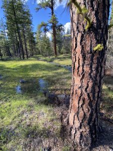
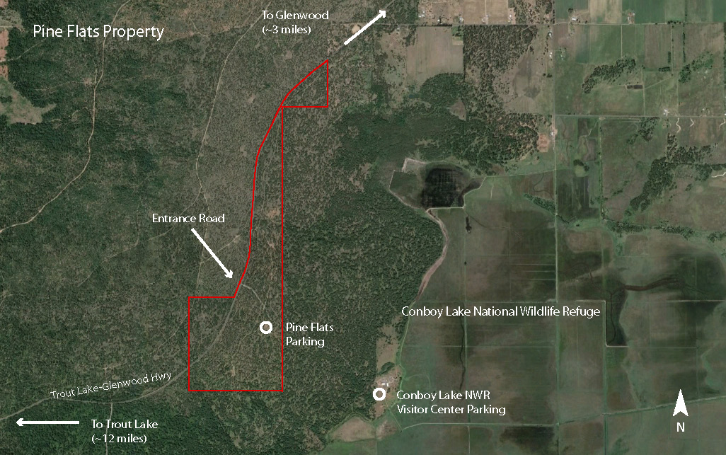 The 300 acre Pine Flats tract is located 4 miles west of Glenwood along the Trout Lake-Glenwood Highway. The property extends for nearly 2 miles of road frontage and includes the entrance road to the headquarters of Conboy Lake National Wildlife Refuge. The tract is adjacent to almost the entire western edge of the wildlife refuge’s headquarters unit. The property was once part of the storied Klickitat Tree Farm. It’s still possible to see the old company rail grade paralleling the county highway in places. The rail line moved logs from Mt. Adams’ forested slopes to the Mill Pond and later, to the sawmill in Klickitat. Ownership has changed hands multiple times over the years, and prior to MARS Pine Flats forests had last been partially logged in the mid-1980s. Most of the Pine Flats tract consists of open ponderosa pine forest. Sandy, well-drained soils and flat topography support an antelope bitterbrush and balsamroot understory. The southern half of the forest was commercially thinned by MARS in the winter of 2015 to provide more light and release the healthiest trees. Planning with refuge fire staff is progressing to implement a prescribed burn in the next year or two that will reduce fuels and rejuvenate the understory. There are not yet formal hiking trails or facilities on the property, but MARS is working on a cross-ownership trail that will link a new track on Pine Flats to existing trails and facilities on Conboy Lake NWR. From March to late May the site is host to a subtle but spectacular wildflower display including balsamroot, rare phantom orchids, scarlet gilia, and the only known population of Suksdorf’s milkvetch in Washington State. Hunting is allowed on the property during approved seasons. Primary access is from the Conboy Lake NWR entrance road off of the Trout Lake-Glenwood Highway. Parking is available off of either side of the road and visitors are welcome to walk off-trail to experience the property. Additional access is from the north along a natural-surface road that parallels the county highway. A cattle guard and barbed wire fence on the eastern border mark the boundary with Conboy Lake NWR, and the highway is the western boundary across most of the site. At all times please be courteous and respectful of the property. It is the responsibility of visitors to know their location and respect the property rights of neighbors and laws governing management of adjacent state and federal lands.
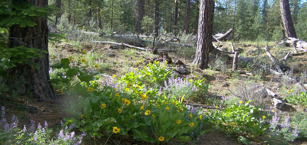
 The Klickitat Rim Tract is a 424-acre addition to the Mt. Adams Community Forest approximately 8 miles east of Glenwood. The property, purchased in 2019, includes a diversity of habitats, from pine-oak woodlands located on flats adjacent to the highway, to dry mixed conifer stands and young plantations in the upper reaches. The tract serves the Mt. Adams Community Forest multiple use goals well, as a location for sustainable harvest of timber shaped by longer rotations to develop high quality logs, and valuable wildlife habitat for western grey squirrels, blacktail deer, black bear and many other species.
 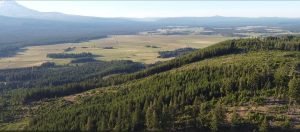 In September of 2023, MARS completed its largest community forest purchase yet: the 800-acre South Conboy Tract that lies adjacent to Conboy Lake National Wildlife Refuge on the BZ-Glenwood Highway. The property is divided between two blocks and is dominated by north facing slopes that were harvested and replanted by the previous landowner. The tract represents some of the most productive tree growing ground within the Mt. Adams Community Forest ownership, while also presenting recreational opportunities, such as hiking and hunting when in-season. MARS will be working with the local community in early 2024 to develop a detailed management plan for the property. https://mtadamsstewards.org/wp-content/uploads/2023/11/South-Conboy-detail.pdf South Conboy detail